Home LiDAR map England Staffordshire
LiDAR map of Staffordshire
Waystone shows the bare-earth LiDAR of Staffordshire at one metre per pixel, with the 4,252 recorded historic places the heritage records hold here, the Roman roads and the Ordnance Survey six-inch maps of 1843–1913 over the same ground. Free, in a browser.
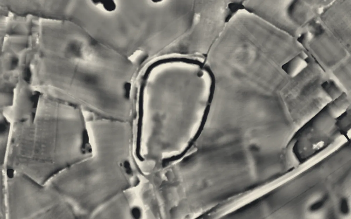
Places on the LiDAR in Staffordshire
Each page shows the site on the LiDAR with its record, its location and the recorded places around it.
- Alton CastleCastle
- Audley's CrossCross
- Berry Ring hillfortHillfort
- Berth HillHillfort
- Brindley Water MillIndustrial site
- Burton AbbeyAbbey
- Castle RingHillfort
- Chatterley Whitfield CollieryIndustrial site
- Croxden AbbeyAbbey
- Dieulacres AbbeyAbbey
- Dove BridgeBridge
- Eccleshall CastleCastle
- Essex BridgeBridge
- Heighley CastleCastle
- Hulton AbbeyAbbey
- Kinver Edge HillfortHillfort
- LetocetumRoman site
- Long LowBarrow
- Madeley Old ManorFortified manor house
- Monks BridgeBridge
- Motte and bailey castle 100m and 200m south of St Mary's SchoolMotte and bailey
- Multivallate hillfort at Bury BankHillfort
- Pillaton HallScheduled monument
- Priory of St. Thomas near StaffordPriory
- Ranton AbbeyPriory
- Tamworth CastleMotte and bailey
- Throwley Old HallScheduled monument
- Timber circle, hengi-form monument and part of a pit alignment at CatholmeScheduled monument
- Tutbury CastleCastle
LiDAR maps of the parishes of Staffordshire
One page for each of the 202 parishes, with a LiDAR picture and the recorded places inside it.
- Abbots Bromley18 recorded places
- Acton Trussell and Bednall25 recorded places
- Adbaston15 recorded places
- Alrewas70 recorded places
- Alstonefield27 recorded places
- Alton30 recorded places
- Anglesey4 recorded places
- Anslow2 recorded places
- Armitage with Handsacre24 recorded places
- Audley Rural41 recorded places
- Bagnall9 recorded places
- Balterley8 recorded places
- Barlaston13 recorded places
- Barton-under-Needwood26 recorded places
- Berkswich22 recorded places
- Betley13 recorded places
- Biddulph95 recorded places
- Bilbrook7 recorded places
- Blithfield20 recorded places
- Blore with Swinscoe24 recorded places
- Blymhill and Weston-under-Lizard39 recorded places
- Bobbington7 recorded places
- Bradley15 recorded places
- Bradnop5 recorded places
- Branston12 recorded places
- Brereton and Ravenhill20 recorded places
- Brewood and Coven86 recorded places
- Bridgtown1 recorded places
- Brindley Heath92 recorded places
- Brizlincote5 recorded places
- Brocton25 recorded places
- Brown Edge5 recorded places
- Burntwood22 recorded places
- Burton55 recorded places
- Butterton4 recorded places
- Cannock Chase44 recorded places
- Cannock Wood12 recorded places
- Caverswall7 recorded places
- Chapel and Hill Chorlton8 recorded places
- Cheadle37 recorded places
- Chebsey7 recorded places
- Checkley22 recorded places
- Cheddleton42 recorded places
- Cheslyn Hay4 recorded places
- Church Eaton23 recorded places
- Clifton Campville10 recorded places
- Codsall12 recorded places
- Colton13 recorded places
- Colwich90 recorded places
- Consall4 recorded places
- Coppenhall4 recorded places
- Cotton15 recorded places
- Creswell3 recorded places
- Croxden12 recorded places
- Curborough and Elmhurst6 recorded places
- Denstone19 recorded places
- Dilhorne12 recorded places
- Doxey3 recorded places
- Draycott in the Clay10 recorded places
- Draycott in the Moors12 recorded places
- Drayton Bassett12 recorded places
- Dunstall5 recorded places
- Dunston5 recorded places
- Eccleshall66 recorded places
- Edingale14 recorded places
- Elford11 recorded places
- Ellastone16 recorded places
- Ellenhall7 recorded places
- Endon and Stanley30 recorded places
- Enville18 recorded places
- Essington10 recorded places
- Farewell and Chorley7 recorded places
- Farley63 recorded places
- Fawfieldhead9 recorded places
- Fazeley15 recorded places
- Featherstone9 recorded places
- Fisherwick15 recorded places
- Forsbrook7 recorded places
- Forton21 recorded places
- Fradley30 recorded places
- Fradswell4 recorded places
- Fulford6 recorded places
- Gayton4 recorded places
- Gnosall36 recorded places
- Great Wyrley10 recorded places
- Grindon16 recorded places
- Hammerwich12 recorded places
- Hamstall Ridware6 recorded places
- Hanbury13 recorded places
- Harlaston4 recorded places
- Hatherton7 recorded places
- Haughton10 recorded places
- Heath Hayes and Wimblebury7 recorded places
- Heathylee6 recorded places
- Heaton5 recorded places
- Hednesford49 recorded places
- High Offley12 recorded places
- Hilderstone4 recorded places
- Hilton4 recorded places
- Himley14 recorded places
- Hints10 recorded places
- Hixon18 recorded places
- Hoar Cross2 recorded places
- Hollinsclough5 recorded places
- Hopton and Coton17 recorded places
- Horninglow and Eton12 recorded places
- Horton15 recorded places
- Huntington14 recorded places
- Hyde Lea3 recorded places
- Ilam28 recorded places
- Ingestre10 recorded places
- Ipstones32 recorded places
- Keele25 recorded places
- Kidsgrove76 recorded places
- King's Bromley12 recorded places
- Kingsley14 recorded places
- Kingstone7 recorded places
- Kinver38 recorded places
- Lapley, Stretton and Wheaton Aston36 recorded places
- Leek58 recorded places
- Leekfrith12 recorded places
- Leigh8 recorded places
- Lichfield92 recorded places
- Loggerheads56 recorded places
- Longdon25 recorded places
- Longnor14 recorded places
- Longsdon13 recorded places
- Lower Penn8 recorded places
- Madeley27 recorded places
- Maer15 recorded places
- Marchington26 recorded places
- Marston5 recorded places
- Mavesyn Ridware28 recorded places
- Mayfield15 recorded places
- Milwich9 recorded places
- Newborough5 recorded places
- Newcastle-under-Lyme92 recorded places
- Norbury28 recorded places
- Norton Canes12 recorded places
- Oakamoor12 recorded places
- Okeover25 recorded places
- Onecote9 recorded places
- Outwoods0 recorded places
- Pattingham and Patshull22 recorded places
- Penkridge63 recorded places
- Perton7 recorded places
- Quarnford10 recorded places
- Ramshorn9 recorded places
- Ranton9 recorded places
- Rocester27 recorded places
- Rolleston on Dove16 recorded places
- Rugeley31 recorded places
- Rushton15 recorded places
- Salt and Enson9 recorded places
- Sandon and Burston15 recorded places
- Saredon4 recorded places
- Seighford21 recorded places
- Shareshill3 recorded places
- Sheen12 recorded places
- Shenstone25 recorded places
- Shobnall10 recorded places
- Silverdale5 recorded places
- Stafford108 recorded places
- Standon14 recorded places
- Stanton11 recorded places
- Stapenhill6 recorded places
- Stoke-on-Trent288 recorded places
- Stone43 recorded places
- Stone Rural34 recorded places
- Stowe-by-Chartley14 recorded places
- Streethay3 recorded places
- Stretton12 recorded places
- Swindon6 recorded places
- Swinfen and Packington9 recorded places
- Swynnerton38 recorded places
- Tamworth67 recorded places
- Tatenhill14 recorded places
- Teddesley Hay13 recorded places
- Thorpe Constantine7 recorded places
- Tittesworth2 recorded places
- Tixall14 recorded places
- Trysull and Seisdon14 recorded places
- Tutbury14 recorded places
- Uttoxeter52 recorded places
- Uttoxeter Rural20 recorded places
- Wall8 recorded places
- Warslow and Elkstones14 recorded places
- Waterhouses50 recorded places
- Weeford3 recorded places
- Werrington8 recorded places
- Weston11 recorded places
- Wetton17 recorded places
- Whitgreave1 recorded places
- Whitmore19 recorded places
- Whittington13 recorded places
- Wigginton and Hopwas16 recorded places
- Winshill6 recorded places
- Wombourne21 recorded places
- Wootton32 recorded places
- Wychnor17 recorded places
- Yarnfield and Cold Meece4 recorded places
- Yoxall18 recorded places
About the LiDAR
The terrain model is made from an airborne laser survey with vegetation and buildings removed, so earthworks show as height: hillfort ramparts, barrows, Roman road banks, hollow ways and ridge and furrow. In the app the picture is computed as you change the settings, with a moveable sun, a local relief model, multidirectional hillshading and the VAT composite. See how to read a LiDAR map and what archaeology looks like on LiDAR.
Sources
- LiDAR: Environment Agency, 1 m composite DTM, Open Government Licence.
- Recorded places: the national heritage records (Historic England, Cadw, Coflein and others) as held by Waystone.
Last updated 2026-10-16.