LiDAR map of Powys
Waystone shows the bare-earth LiDAR of Powys at one metre per pixel, with the 12,612 recorded historic places the heritage records hold here, the Roman roads and the Ordnance Survey six-inch maps of 1843–1913 over the same ground. Free, in a browser.
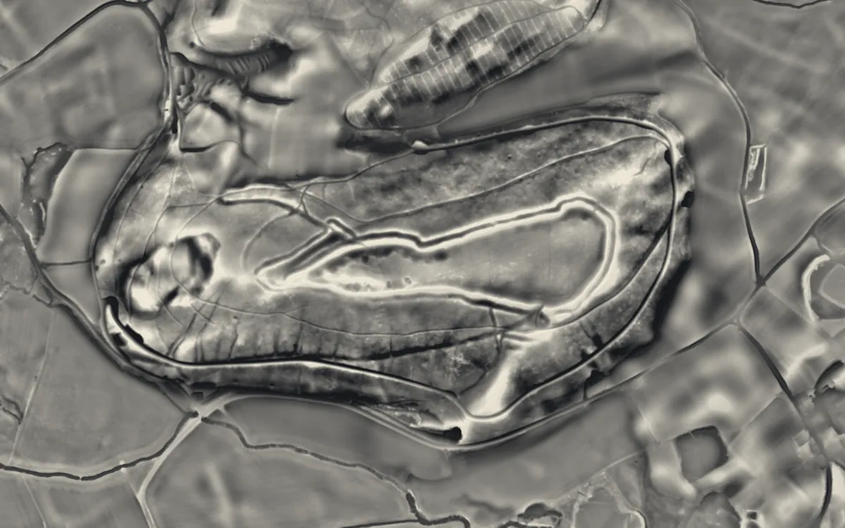
Places on the LiDAR in Powys
Each page shows the site on the LiDAR with its record, its location and the recorded places around it.
- Aberedw CastleCastle
- Aberyscir CastleCastle
- Barland MotteMotte and bailey
- Blaenllyfni CastleCastle
- Bleddfa CastleMotte and bailey
- Boughrood MotteMotte and bailey
- Brecon CastleCastle
- Bronllys CastleCastle
- Bryn-tail LeadworksIndustrial site
- Builth CastleCastle
- Burfa CastleHillfort
- Caer FfordunRoman fort
- Carreghofa CastleMotte and bailey
- Castell DinasCastle
- Castell DuCastle
- Castle NimbleMotte and bailey
- Cefn CarneddHillfort
- CefnllysChapel or church
- Cefnllys CastleCastle
- Coed-y-CaerauHillfort
- Colwyn CastleMotte and bailey
- Crickhowell BridgeBridge
- Crickhowell CastleCastle
- Crug Eryr CastleMotte and bailey
- Crug HywelHillfort
- Cwmhir AbbeyAbbey
- Dolforwyn CastleCastle
- Domen FawrMotte and bailey
- Dyfi BridgeBridge
- Ffridd Faldwyn, MontgomeryHillfort
- Hay CastleCastle
- Hay Tump CastleMotte and bailey
- Hen DomenMotte and bailey
- Llandrinio BridgeBridge
- Llanthomas Castle MoundMotte and bailey
- Llwyn Bryn DinasHillfort
- Maen LliaStone circle
- Maen MadocStone circle
- MathrafalCastle
- Montgomery CastleCastle
- Nantcribba CastleMotte and bailey
- Painscastle CastleMotte and bailey
- Pentre Camp, LlangyniewHillfort
- Porth-mawrMilitary site
- Rhayader CastleCastle
- Roundton HillHillfort
- Slwch TumpHillfort
- Strata MarcellaAbbey
- Sycharth CastleMotte and bailey
- Tinboeth CastleHillfort
- Tomen Bedd UgreMotte and bailey
- Tomen yr AlltMotte and bailey
- Tredustan MotteMotte and bailey
- Tretower CastleCastle
- Tretower CourtFortified manor house
- Usk BridgeBridge
- Y Gaer Roman FortRoman fort
LiDAR maps of the communities of Powys
One page for each of the 110 communities, with a LiDAR picture and the recorded places inside it.
- Abbey Cwmhir30 recorded places
- Aberedw143 recorded places
- Aberhafesp36 recorded places
- Abermule with Llandyssil78 recorded places
- Banwy143 recorded places
- Bausley with Criggion23 recorded places
- Beguildy172 recorded places
- Berriew116 recorded places
- Betws Cedewain15 recorded places
- Brecon118 recorded places
- Bronllys47 recorded places
- Builth23 recorded places
- Cadfarch454 recorded places
- Caersws95 recorded places
- Carno151 recorded places
- Carreghofa52 recorded places
- Castle Caereinion35 recorded places
- Churchstoke75 recorded places
- Cilmery22 recorded places
- Clyro32 recorded places
- Cray43 recorded places
- Crickhowell110 recorded places
- Cwmdu and District220 recorded places
- Disserth and Trecoed43 recorded places
- Duhonw260 recorded places
- Dwyriw70 recorded places
- Erwood166 recorded places
- Felin-fach48 recorded places
- Forden with Leighton and Trelystan123 recorded places
- Gladestry216 recorded places
- Glantwymyn84 recorded places
- Glasbury59 recorded places
- Glascwm239 recorded places
- Glyn Tarell91 recorded places
- Guilsfield49 recorded places
- Gwernyfed50 recorded places
- Hay22 recorded places
- Honddu Isaf19 recorded places
- Kerry98 recorded places
- Knighton47 recorded places
- Llanafanfawr195 recorded places
- Llanbadarn Fawr21 recorded places
- Llanbadarn Fynydd92 recorded places
- Llanbister171 recorded places
- Llanbrynmair247 recorded places
- Llanddew7 recorded places
- Llanddewi Ystradenny32 recorded places
- Llandinam80 recorded places
- Llandrindod Wells81 recorded places
- Llandrinio61 recorded places
- Llandysilio38 recorded places
- Llanelwedd66 recorded places
- Llanerfyl70 recorded places
- Llanfair Caereinion72 recorded places
- Llanfechain24 recorded places
- Llanfihangel67 recorded places
- Llanfihangel Rhydithon20 recorded places
- Llanfrynach225 recorded places
- Llanfyllin37 recorded places
- Llangamarch115 recorded places
- Llangattock302 recorded places
- Llangedwyn38 recorded places
- Llangors63 recorded places
- Llangunllo61 recorded places
- Llangurig280 recorded places
- Llangynidr488 recorded places
- Llangyniew30 recorded places
- Llangynog96 recorded places
- Llanidloes32 recorded places
- Llanidloes Without105 recorded places
- Llanigon79 recorded places
- Llanrhaeadr-ym-Mochnant279 recorded places
- Llansantffraid52 recorded places
- Llansilin37 recorded places
- Llanwddyn87 recorded places
- Llanwrthwl313 recorded places
- Llanwrtyd Wells160 recorded places
- Llanyre36 recorded places
- Llywel184 recorded places
- Machynlleth58 recorded places
- Maescar124 recorded places
- Manafon13 recorded places
- Meifod82 recorded places
- Merthyr Cynog153 recorded places
- Mochdre and Penstrowed22 recorded places
- Montgomery69 recorded places
- Nantmel72 recorded places
- New Radnor82 recorded places
- Newtown and Llanllwchaiarn98 recorded places
- Old Radnor170 recorded places
- Painscastle108 recorded places
- Pen-y-Bont-Fawr33 recorded places
- Penybont168 recorded places
- Presteigne51 recorded places
- Rhayader782 recorded places
- St. Harmon151 recorded places
- Talgarth169 recorded places
- Talybont-on-Usk468 recorded places
- Tawe-Uchaf74 recorded places
- The Vale of Grwyney310 recorded places
- Trallong69 recorded places
- Trefeglwys119 recorded places
- Treflys126 recorded places
- Tregynon34 recorded places
- Trewern48 recorded places
- Welshpool156 recorded places
- Whitton50 recorded places
- Yscir46 recorded places
- Ystradfellte221 recorded places
- Ystradgynlais125 recorded places
About the LiDAR
The terrain model is made from an airborne laser survey with vegetation and buildings removed, so earthworks show as height: hillfort ramparts, barrows, Roman road banks, hollow ways and ridge and furrow. In the app the picture is computed as you change the settings, with a moveable sun, a local relief model, multidirectional hillshading and the VAT composite. See how to read a LiDAR map and what archaeology looks like on LiDAR.
Sources
- LiDAR: Natural Resources Wales and Welsh Government, 1 m DTM, Open Government Licence.
- Recorded places: the national heritage records (Historic England, Cadw, Coflein and others) as held by Waystone.
Last updated 2026-10-16.