Reading the first Ordnance Survey maps
From the 1840s, the Ordnance Survey engraved the names of ancient sites on its six-inch maps in special lettering. We are reading every label on those maps to find them all. Dartmoor, whose sheets came out in the 1880s, is the first area finished, and you can explore it below.
- Each box is one label on the 1880s map. Its colour shows the lettering it was engraved in.
- Click a box to see what it says, how sure we are of it, and which sheet it came from.
- Use the tabs in the panel to switch between our reading, the benchmark’s, and the two compared.
Map images: OS six-inch first edition, © National Library of Scotland. Benchmark reading: the MapReader national run by Katie McDonough’s team, Wood and McDonough (2025), doi:10.5281/zenodo.15101051, CC BY-NC 4.0, shown for non-commercial research. Waystone’s reading: Waystone.
1What we are looking for
From 1842 into the 1890s, the Ordnance Survey mapped England and Wales at six inches to the mile. Scotland was mapped the same way between 1843 and 1882. These maps show the whole country in fine detail, field by field.
The surveyors also marked ancient sites: burial mounds, stone circles, old forts and crosses. Each site’s name was engraved in a style of lettering that showed how old the surveyors thought it was.
So the map is a record of what the Victorians believed was ancient, place by place. Many of those sites are in today’s heritage records. Some may not be. To find them, we first need to read every label on the map. That is what this project does.
What we have found so far
- Every labelread on Dartmoor, the first area finished. See the map
- of labels given the right lettering style in a test on counties our model had never seen. The test
- ancient-site labels on Dartmoor read exactly. The comparison
Words used on this page
- Label
- A name or word engraved on the map, such as Tumulus or Fox Tor.
- Lettering style
- The style a label was engraved in. The Survey set a style for each kind of name, and many kinds shared one.
- Antiquity
- The Survey’s word for an ancient site. A tumulus is a burial mound.
- Benchmark
- An earlier reading of the same maps by the MapReader team, published in 2025. We measure our results against it.
- Test area
- A patch of map where every word has been written out beforehand, so our reading can be scored.
2How the archaeology got onto the map
A label on an old map is evidence. Like any evidence, it is only as good as its source. This is how a name reached the map.
- Asked on the ground
The Survey’s field staff worked through each parish. They asked the people who lived there what each place was called: landowners, clergy, schoolmasters.
- Written in the Name Book
Each name went into a ledger, the Object Name Book, with the people or books that vouched for its spelling.
- Engraved on the map
The name was engraved in the lettering style set for that kind of place.
One site, four descriptions
Cairnpapple Hill in West Lothian shows why the date of a label matters. Each generation described it differently.
| When | Recorded in | What it was called |
|---|---|---|
| 1850s | The Object Name Book, at the first survey. The hill’s own entry adds “an ancient British Camp much defaced”. | “Fort” |
| 1850s | The first six-inch map, Linlithgowshire sheet 5 | “Fort” |
| 1895 | The Ordnance Survey 25-inch map | “Fort” |
| 1954 | The Ordnance Survey 1:2,500 map | “Henge Monument and Cairn” |
| Today | Canmore, Historic Environment Scotland’s record | A Neolithic henge and a Bronze Age cairn |
By today’s knowledge the early descriptions are wrong. The Library’s guide notes that the Rev. J. Duns wrongly claimed the site was a British camp. But each description records what people thought at the time. So we keep the date of every label and read it by the rules of its day.
Further reading from the National Library of Scotland Researching Archaeology on Historic Maps The Library’s guide follows how ancient sites were shown on maps, from Ptolemy and William Roy to the Survey’s Name Books and its post-war Archaeology Division, and how to read them with care.How the map fed today’s records
Today, ancient sites are recorded by Historic England, by the Royal Commission and Cadw in Wales, by Historic Environment Scotland, and in local Historic Environment Records. Part of that record began with the Survey’s own work on its maps. In 1947 the Survey set up an Archaeology Division, and the card index of antiquities it built in the late 1940s became an important foundation of today’s national records.
- The Survey’s maps
Antiquities marked on Ordnance Survey maps.
- Late 1940s
The Survey’s card index of antiquities.
- Today
The national heritage records.
So when the old map and a modern record agree about a site, some of that agreement may be inherited rather than independent. Twentieth-century fieldwork also checked the old maps again, so how much is inherited is an open question. We plan to measure it, by comparing records backed by independent evidence, such as excavation or aerial survey, with the rest.
3The lettering
In November 1881 the Survey issued an internal rule sheet, OS 404, Character of Writing for Ordnance Survey Plans. It set the lettering style for every kind of name. Many kinds shared a style: farms, single houses and streams were all in Stump, a sloping hand. Ancient sites had three styles, one for each period.

Character of Writing for Ordnance Survey PlansOS 404, November 1881
The first page lists the abbreviations, then begins the table. The marked rows are the antiquities: Roman sites in Egyptian Capitals (E.C.), “Druidical or Saxon” in Old English, and “Norman or Subsequent” in German Text, at every scale.
Click a page to open it full size. Scans: National Library of Scotland, Map X3.234. The circular as a PDF
- Egyptian Capitals
- Roman sites.
- Old English
- Sites the surveyors judged “Druidical or Saxon”. In today’s words, prehistoric or early medieval.
- German Text
- Sites judged “Norman or Subsequent”: from the Norman Conquest on.
So the lettering tells you two things: that the surveyors thought a place was ancient, and roughly how old they thought it was.
Try the lettering
Type a name to see it in four of the Survey’s lettering styles. We rebuilt these styles from the Survey’s own printed alphabet plates of 1934.
- MerrivaleOld English“Druidical or Saxon” sites
- MerrivaleGerman Text“Norman or Subsequent” sites
- MerrivaleRoman PrintWoods, parish villages, terraces
- MerrivaleStumpFarms, single houses, streams. Shown in our Italic, the nearest face we have.
Old English or German Text?
These two are the hardest to tell apart, and the difference matters. One means prehistoric or Saxon, the other Norman or later. Comparing the Survey’s specimen sheets, we find the clearest difference at the foot of the letters.
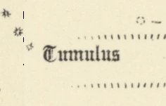
Old English Upright, angular strokes, cut off square at the line the letters stand on.
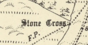
German Text Rounder letters. When engraved, fine hairline tails dip below that line.
The rule changed over time
The meaning of each style did not stay fixed. On the sheets for England and Wales, the Survey’s wording for Old English changed from “Druidical or Saxon” to “Pre-historic or Saxon”. Ifan Shepherd traced this change across the county index sheets, and we thank him for his help with this part of the work. The years printed on those sheets place the change between 1885 and 1888.

1847 “Druidical or Saxon”

1897 “Pre-historic or Saxon”
Most of Dartmoor’s sheets were published during those years. So we read each label by the wording in force when its own sheet was published.
Show as a table
In 1921 O. G. S. Crawford, the Survey’s Archaeology Officer, set out a new rule: Saxon sites would move to German Text, with the medieval. How soon the six-inch maps followed is not clear. Plate IV, a six-inch specimen annotated 1923, still prints the older wording.

4How we read the map
Where we started
We did not start from scratch. This work builds on Katie McDonough’s. She led the UK side of Machines Reading Maps, a British and American research project that set out to turn the words on historical maps into data that can be searched. Later, at The Alan Turing Institute, her MapReader team read the words on the six-inch first edition across Great Britain. Rosie Wood and Katie McDonough published the result in 2025.
That reading is our benchmark. Every result on this page is measured against it.
Wood and McDonough (2025), MapReader_text_OS_6_inch_1st_edition. Zenodo. doi:10.5281/zenodo.15101051. CC BY-NC 4.0.
Five steps for every label
Every label goes through the same five steps. Here they are for one real label: a burial mound on south-west Dartmoor.
-
1Find it
We find the lettering and draw a box round it.
-
TumulusThe reading2Read it
We read the letters inside the box.
-
Old EnglishLettering style3Name the style
We name the lettering style it was engraved in.
-
Ancient site, prehistoric or SaxonSheet published 18864Find the meaning
We look up what that style meant when the sheet was published.
-
TumulusA burial moundDevonshire CXIII.SWPublished 18865Add it to the map
We put it on the map with its sheet and date.
We only mark a reading as sure when we are confident it is right.
5How well it works
To score a reading, you need the right answers. So before scoring anything, we wrote down the right answer for every item in three test sets: exactly what each word says in two of them, and each label’s lettering style in the third.
- The Erme test area
- 3 by 2 km of the upper Erme valley on Dartmoor: 105 lines of lettering. A second, separate check went over it word by word. It redrew seven outlines and changed no reading.
- Dartmoor’s ancient sites
- 27 lines of blackletter antiquity lettering from across Dartmoor. It is sealed and waits for the same second check.
- The lettering test
- Labels from counties kept apart while the models learned. Each model we tried was scored on it once.
A line counts as found when one of our boxes is centred on it. It counts as read when every letter matches.
The Erme test area
How many of the test area’s lines each reading finds, and how many it reads exactly.
Show as a table, with three more measures
Dartmoor’s ancient-site labels
The labels this project is most interested in: the antiquities.
Naming the lettering style
How often we name the right lettering style, tested on labels from counties our model had never seen.
How it has improved
Each point is one complete run over the whole of Dartmoor, scored on the same test sets. Hover or focus a point to see what changed.
Show as a table
What these figures do not tell you
The Erme test area has guided the work, and the ancient-site set has been scored after each run. So their figures are likely to be better than you would get on new ground.
For a fair figure we have prepared a fresh test area in Gloucestershire. The county was held out from all training, and nothing had been run there before its words were written down. Its result will be the figure to quote.
6Where the work stands
| Part of the work | Where it stands | Latest result |
|---|---|---|
| Finding the labels | ||
| Reading the words | ||
| Naming the lettering style | ||
| Reading the ancient-site labels | ||
| The Dartmoor map | ||
| The earthwork detector | In preparation | Examples from 1,865 monuments gathered. Not in the app. |
What comes next
- Score the fresh Gloucestershire test area, once.
- Move on from Dartmoor to further areas of the map.
- Show what the first edition said about each place on Waystone’s own map. That map holds about 850,000 recorded places, and Waystone’s research library holds 203,888 documents.
- When the models are finished, they will be released as open source.
The earthwork detector
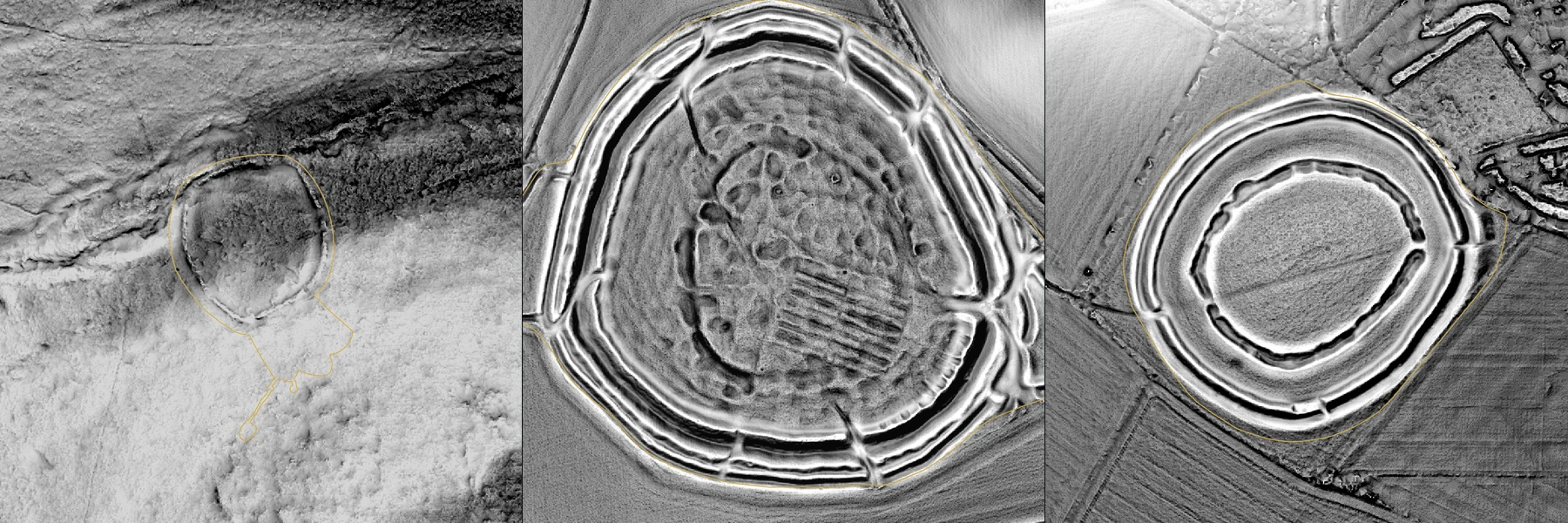
An earthwork is a bank, ditch or mound left by past building. LiDAR is a laser survey flown from an aircraft. With the trees and buildings taken out, it shows the shape of the bare ground, and earthworks stand out in it.
We are preparing a machine-learning model to spot earthworks in LiDAR. It will learn from 1,865 scheduled monuments in England, sites protected by law. It will always be tested on ground it has not learned from, and it will produce a ranked list for an archaeologist to check, never a discovery on its own.
Where an 1880s map names an ancient site that today’s records do not hold, that ground will become a place for the detector to look. It is still in preparation, and it is not in the app.
7Research log
Every change that moved a result, newest first.
8Sources and thanks
- The benchmark
- Katie McDonough, Rosie Wood and the MapReader team at The Alan Turing Institute (Living with Machines; Data/Culture). This work builds on their national reading of the first edition and is measured against it: Wood and McDonough (2025), doi:10.5281/zenodo.15101051, CC BY-NC 4.0. Katie McDonough also led the UK side of the Machines Reading Maps project.
- Dating the lettering
- Ifan Shepherd, whose work on the county index sheets traced the Survey’s change from “Druidical” to “Pre-historic”. With thanks for his help. The dates on this page, 1885 to 1888, come from the years printed on those sheets.
- The maps
- National Library of Scotland: the six-inch first-edition images, the sheet index that dates every label, the OS 404 circular (Map X3.234), and the guide Researching Archaeology on Historic Maps.
- The record
- Hart, J. and Leech, R. (1989), “The National Archaeological Record”, CAA 1989 proceedings, pp. 57–67. Crawford, Notes on Archaeology for Guidance in the Field, Ordnance Survey (1921). National Records of Scotland, OS1/34/55. Canmore (now trove.scot) site 47919. Environment Agency National LiDAR Programme and Historic England, Open Government Licence.
Figures on this page change as new results are scored, and each change is dated in the research log. None of this work is in the Waystone app yet.